Feature Projects:
Kaihu tidal flood modelling
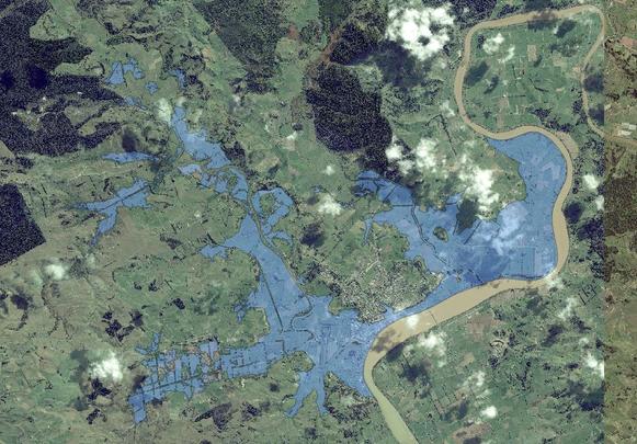
Hydraulic models of the Kaihu valley (a Mike 11 model) and of the Awakino floodplain, Dargaville, and the lower Kaihu valley (a Tuflow model) were used to simulate flooding due to three extreme tide events: 1% annual exceedance probability (AEP) under present day (2016) conditions; 2% AEP with projected sea level rise to 2065; and 1% AEP with projected sea level rise to 2115. The maximum tidal levels in those events in terms of One Tree Point Datum (OTP) are 2.9m, 3.3m, and 3.9m, respectively. The hydraulic models were developed and calibrated in a previous river flood hazard study for Kaihu valley, Dargaville, and the Awakino floodplain carried out by Barnett & MacMurray Ltd for Northland Regional Council (NRC). The maximum tidal flood extent is significantly less than it would be if the flood level was everywhere equal to the maximum tidal level: for example at 2-3km from the Northern Wairoa River, the maximum flood level was approximately 300mm lower than the maximum tidal level. Grids of maximum water level, maximum depth, and maximum velocity (in the Tuflow model area), and shape files of tidal flood extent, were supplied to NRC.