We cover most aspects of hydrological and hydraulic engineering, and have skills in the following:
Hydraulic modelling of rivers, lakes and pipe networks
Barnett and MacMurray have built hydraulic models ranging from short stream reaches up to a model of the entire Waikato River. Our river hydraulic models have been used for river capacity assessment and stopbank design, investigating flooding or low flow issues, and estimating flood levels.
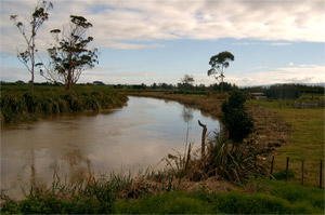 Kaihu River, Northland
Flood inundation studies and flood mapping
If a hydraulic model is used to investigate major flood events, flood extent on adjacent land is often required. We have done many investigations where the hydraulic model is extended so that the river channel can overflow onto linked floodplain areas, showing any resulting inundation.
We have efficient systems for processing hydraulic model results into maps of flood depth, flow velocity or a combination of the two for ease of viewing. This allows quick identification of the affected areas and the severity of the flood hazard.
Flood studies are a useful tool for planning purposes and risk assessment. Increasingly flood studies are used to aid in zoning decisions which mitigate flood risk. Our flood studies have been used to determine safe floor levels, identify overland flow paths and bottlenecks in the drainage network, and facilitate management in emergency flood situations.
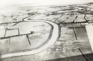 Flooding on Piako River, Pipiroa, 1938 (image courtesy of Waikato Regional Council)
Flood control scheme concept design
Evolving land use causing increased runoff during storms and settlement of marginal floodplain areas are leading to more flood issues throughout New Zealand. Hydraulic models of rivers and floodplains give the client flexibility to test potential solutions to flood issues. Once developed, the model can be used multiple times to evaluate the effectiveness of flood mitigation options as part of a cost benefit analysis.
Sediment transport and morphological modelling
Study of how sediment moves through a river system and how the morphology (shape) of the river changes as a result. Sediment is continuously eroding from the land and being carried by rivers to the sea. Of particular interest are places where the sediment balance is not in equilibrium i.e.: more sediment is carried away than deposited, causing lowering of a river invert and undermining of its banks, or where more sediment is deposited than removed, causing the river bed to aggrade and increasing potential flood risk.
We attempt to model how sediment is transported in the river, and ultimately to understand the underlying morphological processes. If a morphological model can be calibrated it can be used to forecast how the river may change over the longer term. Our studies have been used to determine the sediment transport for a given river reach, or what effect a disturbance such as dredging or sediment removal might have on the river.
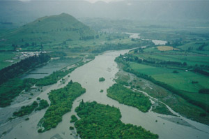 Shotover delta in flood, 1999 (image courtesy of ORC)
Expert witness on hydraulics, sediment transport and river morphology
Land and water issues can be contentious, and sometimes a client may find themselves defending their activity, local river or plan change in Court. Barnett and MacMurray Ltd have experience in preparing and giving evidence on issues relating to hydraulics, such as the placement of structures in rivers, stopbank effects and flood control schemes.
As hydraulic engineering specialists we can understand the technical aspects of difficult hydraulic questions and are able to communicate conclusions clearly to people from a variety of non-engineering backgrounds; a vital skill in the courtroom.

Dam break analysis
Breach analysis forms part of hazard assessment for dams in New Zealand. Using an accurate model of the reservoir, the dam crest, bottom outlets or spillways we can model the breach of the dam. A breach is often simulated under heavy rainfall conditions so that reservoir inflows are high. The effects of the breach are then investigated in a model of the waterways downstream of the dam. The model will also contain secondary flow paths where the breach flow leaves the river channels and crosses roads or takes alternate routes downstream. The resulting flooding can be mapped for depth and flow velocity to help assess which areas will be most seriously affected.
Hydrological modelling and flood frequency analysis
Hydrological services include water resource studies, statistical analysis of flow records, and rainfall runoff modelling. Water resource studies are useful for irrigation and hydro power schemes, where long term catchment runoff behaviour is important. We can estimate design flood flows from frequency analysis, desktop calculations, rainfall runoff modelling or a combination of these. Flow time series produced by calibrated hydrological models are used as input for hydraulic models in catchment or flood studies.
Bridge waterway design
Desktop calculations or hydraulic modelling are used to design the optimum bridge waterway for a given site, or to assess problems at an existing bridge, such as overtopping or scour. Using the Aulos software we can directly apply the empirical loss factors given by books such as Chow (Open Channel Hydraulics).
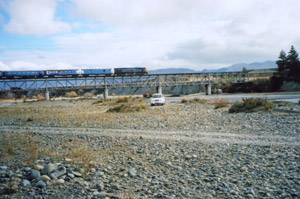 Awatere River bridge
Hydro power scheme analysis
Hydro power schemes are a special case of river modelling, where the river system may include a dam and penstocks, canals, gates, and pumps. Barnett and MacMurray Ltd have experience in modelling these regulated and often complicated systems. Our work has covered concept design for hydro power schemes, design flood and minimum flow simulations, refining operating rules and optimising water resource use.
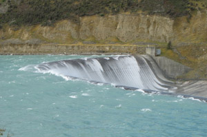 Waitaki Dam spilling, Waitaki River, Otago
Urban drainage concept and consent planning
In order to comply with the relevant acts and with local government regulations it is often necessary to conduct rigorous urban stormwater assessments. Barnett and MacMurray Ltd are able to design drainage concepts, simulate rainfall-runoff and evaluate system performance. We have prepared effects assessments for drainage design, and prepared expert testimony for hearings.
Urban stormwater modelling and analysis
Stormwater systems are typically a combination of open channels and pipelines with multiple inflows and outflows. With many links, transitions, and the small model scale they can be challenging to model. We use hydrological and hydraulic modelling software packages that have been carefully selected to be of the highest accuracy for such investigations. Studies Barnett and MacMurray Ltd have been involved in include capacity testing, specifying design flood levels, identifying flood hazard areas, and evaluating proposed network upgrades.
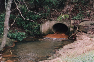 Stormwater culvert, Western Heights, Rotorua
Tsunami and coastal studies
Long waves present a particularly serious risk to water side dwellers. Events such as a tsunami; a series of deep waves caused by a displacement of a large volume of water in the ocean (termed seiching in a lake); travel fast and possess enormous destructive energy. Water levels on the coast or shore of a large water body can also be driven up by wind driven surface waves, or storm surge caused by atmospheric conditions.
With a specialised software module we are able to model the generation of long waves in detail. Given reasonable bathymetry for lake or coastal areas, we can track the development of the wave and any oscillations.
We have used this technology to investigate coastal tsunami effects, seismic seiching in hydro lakes, assess storm surge and inland landslide wave hazard. This work is also applicable to seismic shaking or other displacement effects in reservoirs and studies of longer term coastal wave effects.
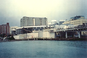 High tide on inner Lambton Harbour, Wellington